Toronto, Ontario, June 21, 2022 – Grid Metals Corp. (the "Company") (TSXV:GRDM) (OTCQB:MSMGF) is pleased to report additional drilling results from the Phase 1 drill program at its Donner Lake lithium property (the "Property") in southeastern Manitoba. In addition, the Company has started field work at the Property that will initially focus on sampling of several previously mapped pegmatite dykes. The project is located in the Winnipeg River pegmatite field, which hosts the world-class Tanco pegmatite and the associated Tanco lithium-cesium-tantalum mine and concentrator. The project is a 75%/25% joint venture between Grid Metals Corp and Lithium Royalty Corp., a leading player in global lithium finance.
Drilling Highlights:
- New drill intersections of the Northwest Dyke include the following length-weighted average grades:
- 8.2 metres averaging 1.53% Li2O in GDL22-07 (from 103.5 metres) including 5.5 metres averaging 1.96% Li2O
- 14.6 metres averaging 1.25% Li2O in GDL22-11 (from 141.7 metres) including 5.8 metres averaging 1.74% Li2O
- 3.26 metres averaging 1.88% Li2O in GDL22-14 (from 178.8 metres)
- Anomalous cesium and tantalum values were also encountered in the new holes including maximum individual sample grades of 2850 ppm Cs2O (GDL22-11) and 509 ppm Ta2O5 (GDL22-10).
The Northwest Dyke has been traced by drilling for ~600 metres along strike and to a vertical depth of ~250 metres. It is the second drill-defined LCT type pegmatite with significant strike length on the Donner Lake property. Similar lithium grades were previously reported for the Company’s 2018 drill holes targeting the Main Dyke, which is located ~1.5 km to the east of the Northwest Dyke. Note that the Northwest Dyke intersection lengths reported above do not represent the true thickness of the dyke, which is estimated to typically range from 4 to 8 metres, representing 50-70% of the reported intersection lengths. Complete analytical results for hoes GDL22-07, -10, -11 and -14, together with drill hole specifications for these and previously reported holes, are provided in the Appendices accompanying this release. Hole locations are shown on the accompanying plan view map and longitudinal section. Core photos from the newly reported holes are included below.
Field Program Underway
The Company has mobilized geological crews to the property to sample the known pegmatite dykes on the property. Known pegmatite dykes include the West Dyke swarm, the South Dykes and several other pegmatites on the east part of the property that were mapped by Grid in 2012. A map showing the location of the target dykes is attached. Follow up work will include a lithogeochemical survey to vector to unexposed LCT type pegmatites.
The property is viewed by Grid as very prospective for other lithium bearing LCT type pegmatite dykes. The focus is on identifying new drill targets to complement the Northwest and Main Dykes which have been the target of drilling to date.
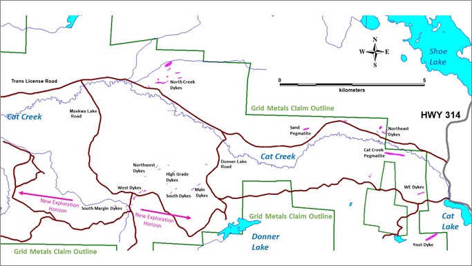
Above: Map showing location of mapped pegmatites on Grid’s Mayville – Donner Lake claim block.
Mr. Carey Galeschuk, Grid’s Vice President, Lithium Exploration, stated, "We continue to see consistently good widths of high-grade lithium from the recent Northwest Dyke drilling. In addition to our drilling we look to rapidly progress the Donner Lake discovery process with the identification of new drill targets in the field. With the combination of results to date, geological prospectivity and access to infrastructure we view the project as having great potential."
Quality Assurance and Quality Control
Grid Metals applies best practice quality assurance and quality control ("QAQC") protocols on all of its exploration programs. For the Donner Lake drilling program, core was logged and sampled at the Company’s core facility located on the Makwa Property. Generally, 1.0 metre sample lengths were used. Samples were bagged and tagged and then transported by secure carrier to the Actlabs (Thunder Bay) laboratory for sample preparation and analysis for lithium, cesium, tantalum and selected major and trace element abundances using a sodium peroxide fusion total digestion method followed by ICP-OES and ICP-MS analysis. The Company is using two lithium + rare metal certified reference materials ("CRMs") and two analytical blanks for the Donner Lake program to monitor analytical accuracy and check for cross contamination between samples.
Dave Peck, P.Geo., has reviewed the contents of this press release and is the qualified person for purposes of National Instrument 43-101.
About the Donner Lake Lithium Property
- The Property is owned 75% by Grid Metals Corp. and 25% by Lithium Royalty Corp. (LRC), which is funding 25% of the current exploration program. LRC holds an overriding 2% royalty on the property.
- The Property was acquired by Grid from Tantalum Mining Corporation of Canada Limited (Tanco) which has the first right to acquire products produced from the property at commercial terms and holds a 2% royalty on certain claims.
- Sinomine Canada is currently operating a lithium spodumene circuit at its Tanco Mine facility, located approximately 35 km to the southwest of the Donner Lake Property.
- Donner Lake is only 180 km from the provincial capital of Winnipeg and accessible by all season roads and logging trails and there is nearby access to Canada’s major east-west railway line.
- Grid Metals has an exploration agreement in place with the Sagkeeng First Nation, whose Traditional Lands include the Donner Lake and Mayville properties.
- The Property has nearby access low-cost renewable power from Manitoba’s extensive hydro-electric grid.
- There are multiple LCT-type pegmatite dykes on the Property including the Main Dyke that, in 2018, was drill tested by Grid over a ~1 km strike length. The dykes are located along a ~9 km long prospective geological contact between the Bird River greenstone belt and the Makwa Lake batholith and occupy obvious structural trends.
- The Main Dyke and Northwest Dyke together supported a non-compliant historical resource estimate of 3.8 million tons at a grade of 1.28% Li2O (Manitoba Mines Branch Assessment file 91769A). This resource estimate cannot be independently verified by the Company. The Company is looking to complete resume drilling later this year to establish a maiden NI 43-101 lithium resource and continue exploration for other LCT-type pegmatites on the Property.
- The Property is significantly underexplored with a large portion of the prospective geology having seen no prior lithium exploration.
About Grid Metals Corp.
Grid Metals Corp. maintains an attractive portfolio of exploration and development stage properties focused on battery metals (nickel, lithium, copper, cobalt, platinum group metals cobalt) and emission reduction technologies (palladium, platinum, rhodium) in the Provinces of Manitoba and Ontario, Canada. The Company is currently focused on advancing both its Donner Lake lithium and its PEA stage Makwa-Mayville Cu-Ni-PGM-Co assets in southeastern Manitoba.
To find out more about Grid Metals Corp., please visit www.gridmetalscorp.com.
On Behalf of the Board of Grid Metals Corp.
Robin Dunbar - President, CEO & Director
Telephone: 647 201 6844 Email: rd@gridmetalscorp.com
David Black - Investor Relations Email: info@gridmetalscorp.com 416 955-4773
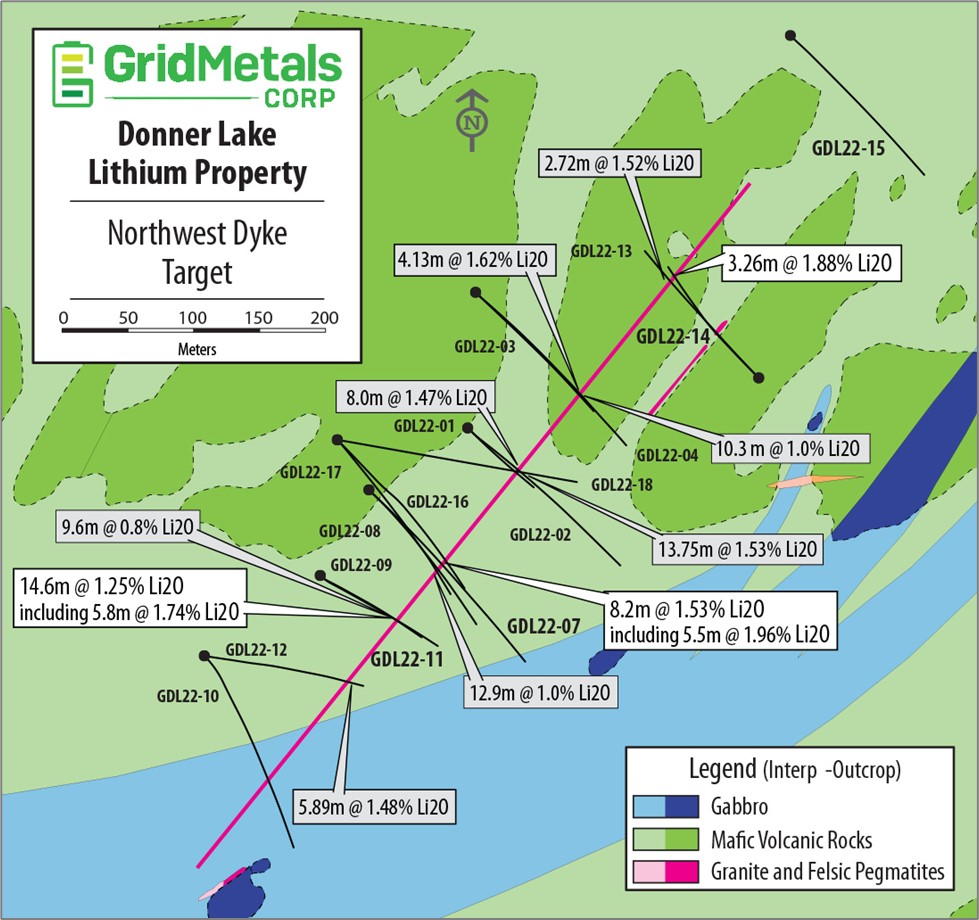
Above: 2022 drill hole locations from the Northwest Dyke exploration program at the Donner Lake Lithium Property showing the current surface projection of the main pegmatite body (thick pink line) and the Li2O grades obtained for previously and newly reported (larger font) holes.
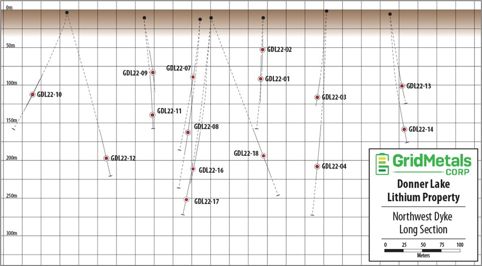
Above: Longitudinal section, looking west, showing relative 3D position of the February-April 2022 drill hole pierce points into the Northwest Dyke, Donner Lake Lithium Property.
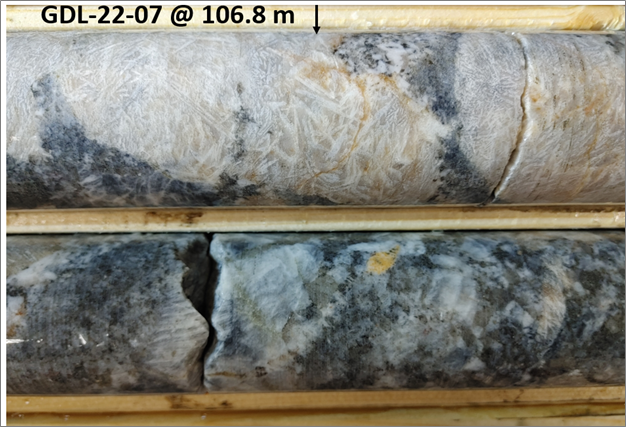
Above: White spodumene blades in GDL-22-07 at 106.6 meters downhole.
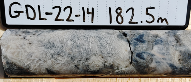
Above: Spodumene-quartz intergrowths (SQUI) from GDL-22-14 at 182.5 meters downhole.
Appendix 1: Analytical Results, Drill Hole GDL22-07, Northwest Pegmatite Dyke, Donner Lake Lithium Property, Southeastern Manitoba.
| Sample# | From (m) | To (m) | Length (m) | Li2O (%) | Ta2O5 (ppm) | Cs2O (ppm) | Rb2O (%) |
| AM753408 | 103.45 | 104.27 | 0.82 | 1.03 | 126 | 193 | 0.22 |
| AM753409 | 104.27 | 104.37 | 0.10 | 0.69 | 0.9 | 356 | 0.17 |
| AM753411 | 104.37 | 104.60 | 0.23 | 0.67 | 133 | 75.3 | 0.10 |
| AM753412 | 104.60 | 105.52 | 0.92 | 0.76 | 125 | 194 | 0.31 |
| AM753413 | 105.52 | 106.50 | 0.98 | 2.14 | 54.0 | 118 | 0.22 |
| AM753415 | 106.50 | 107.50 | 1.00 | 1.52 | 60.9 | 159 | 0.28 |
| AM753416 | 107.50 | 108.50 | 1.00 | 1.68 | 67.1 | 159 | 0.26 |
| AM753418 | 108.50 | 109.50 | 1.00 | 2.11 | 33.2 | 82.7 | 0.17 |
| AM753419 | 109.50 | 110.50 | 1.00 | 2.12 | 43.3 | 104 | 0.26 |
| AM753421 | 110.50 | 110.98 | 0.48 | 2.39 | 42.5 | 92.2 | 0.16 |
| AM753422 | 110.98 | 111.65 | 0.67 | 0.16 | 61.3 | 164 | 0.34 |
| Interval Averages | |||||||
| 103.5 | 111.7 | 8.2 | 1.53 | 69.2 | 142 | 0.24 | |
| inc. | 105.5 | 111.0 | 5.5 | 1.96 | 50.9 | 122 | 0.23 |
Appendix 2: Analytical Results, Drill Hole GDL22-10, Northwest Pegmatite Dyke, Donner Lake Lithium Property, Southeastern Manitoba. Note in this hole there were multiple narrow intercepts of mineralogically distinctive pegmatite dykes separated by inclusions of basalt. A narrow intersection of the Northwest Dyke was encountered between 155.4m and 156.65m.
| Sample# | From (m) | To (m) | Length (m) | Li2O (%) | Ta2O5 (ppm) | Cs2O (ppm) | Rb2O (%) |
| 856486 | 148.30 | 148.66 | 0.36 | 0.04 | 370 | 97.5 | 0.13 |
| 856487 | 148.66 | 148.68 | 0.02 | 0.20 | 279 | 366 | 0.28 |
| 856488 | 148.68 | 149.95 | 1.27 | 0.02 | 206 | 97.5 | 0.14 |
| 856491 | 153.38 | 153.48 | 0.10 | 0.04 | 509 | 92.2 | 0.02 |
| 856494 | 154.56 | 154.75 | 0.19 | 0.62 | 178 | 201 | 0.28 |
| 856497 | 155.40 | 156.00 | 0.60 | 1.35 | 114 | 141 | 0.22 |
| 856498 | 156.00 | 156.65 | 0.65 | 1.28 | 105 | 191 | 0.29 |
| 856500 | 157.15 | 157.35 | 0.20 | 0.12 | 157 | 368 | 0.14 |
| AM753309 | 173.90 | 174.07 | 0.17 | 0.06 | 118 | 94.4 | 0.10 |
| AM753311 | 175.12 | 175.34 | 0.22 | 0.03 | 70.8 | 44.5 | 0.02 |
| AM753318 | 179.15 | 179.52 | 0.37 | 0.02 | 164 | 90.1 | 0.07 |
| AM753324 | 184.90 | 185.30 | 0.40 | 0.47 | 75.8 | 148 | 0.24 |
| AM753325 | 185.30 | 185.60 | 0.30 | 0.28 | 88.0 | 157 | 0.26 |
| AM753327 | 186.67 | 187.10 | 0.43 | 0.03 | 76.8 | 125 | 0.23 |
| AM753332 | 201.35 | 201.90 | 0.55 | 0.04 | 61.7 | 476 | 0.43 |
|
|
|
| ||||
| Interval Averages |
|
|
|
| |||
| Granitic Dyke | 148.30 | 149.95 | 1.65 | 0.03 | 243 | 101 | 0.14 |
| NW Dyke | 155.40 | 156.65 | 1.25 | 1.31 | 109 | 167 | 0.26 |
Appendix 3: Analytical Results, Drill Hole GDL22-11, Northwest Pegmatite Dyke, Donner Lake Lithium Property, Southeastern Manitoba.
| Sample# | From (m) | To (m) | Length (m) | Li2O (%) | Ta205 (ppm) | Cs20 (ppm) | Rb2O (%) |
| AM752704 | 141.70 | 142.42 | 0.72 | 1.29 | 215 | 264 | 0.40 |
| AM752706 | 142.42 | 142.80 | 0.38 | 0.13 | 1.70 | 109 | 0.05 |
| AM752707 | 142.80 | 143.10 | 0.30 | 1.39 | 203 | 290 | 0.28 |
| AM752708 | 143.10 | 143.25 | 0.15 | 0.81 | 75.0 | 2851 | 0.55 |
| AM752709 | 143.25 | 144.00 | 0.75 | 1.80 | 230 | 480 | 0.40 |
| AM752711 | 144.00 | 144.40 | 0.40 | 0.24 | 222 | 740 | 0.43 |
| AM752712 | 144.40 | 145.00 | 0.60 | 1.62 | 233 | 392 | 0.37 |
| AM752713 | 145.00 | 145.65 | 0.65 | 1.63 | 177 | 390 | 0.40 |
| AM752714 | 145.65 | 146.25 | 0.60 | 0.29 | 3.85 | 342 | 0.11 |
| AM752716 | 146.25 | 147.05 | 0.80 | 1.41 | 173 | 200 | 0.25 |
| AM752717 | 147.05 | 147.65 | 0.60 | 0.56 | 155 | 335 | 0.27 |
| AM752718 | 147.65 | 147.95 | 0.30 | 1.44 | 148 | 251 | 0.28 |
| AM752719 | 147.95 | 148.80 | 0.85 | 0.22 | 89.6 | 145 | 0.23 |
| AM752721 | 148.80 | 149.80 | 1.00 | 1.91 | 48.8 | 110 | 0.21 |
| AM752722 | 149.80 | 150.85 | 1.05 | 1.35 | 79.9 | 142 | 0.28 |
| AM752723 | 150.85 | 151.85 | 1.00 | 1.67 | 63.5 | 155 | 0.28 |
| AM752724 | 151.85 | 152.85 | 1.00 | 1.71 | 74.2 | 174 | 0.29 |
| AM752726 | 152.85 | 153.85 | 1.00 | 1.81 | 50.9 | 135 | 0.32 |
| AM752727 | 153.85 | 154.65 | 0.80 | 2.10 | 51.0 | 119 | 0.24 |
| AM752728 | 154.65 | 155.18 | 0.53 | 0.85 | 40.7 | 158 | 0.39 |
| AM752729 | 155.18 | 156.31 | 1.13 | 0.29 | 84.3 | 144 | 0.31 |
| Interval Averages | |||||||
| 141.70 | 156.31 | 14.61 | 1.25 | 108 | 255 | 0.29 | |
| inc. | 142.80 | 145.65 | 2.85 | 1.41 | 206 | 582 | 0.39 |
| and | 146.25 | 156.31 | 10.06 | 1.30 | 82.6 | 161 | 0.28 |
| with | 148.80 | 154.65 | 5.85 | 1.74 | 61.9 | 140 | 0.27 |
Appendix 4: Analytical Results, Drill Hole GDL22-14, Northwest Pegmatite Dyke, Donner Lake Lithium Property, Southeastern Manitoba.
| Sample# | From (m) | To (m) | Length (m) | Li2O (%) | Ta (ppm) | Cs (ppm) | Rb2O (%) |
| AM752876 | 178.41 | 178.86 | 0.45 | 0.15 | 114 | 270 | 0.40 |
| AM752877 | 178.86 | 179.86 | 1.00 | 0.21 | 76.5 | 241 | 0.26 |
| AM752878 | 179.86 | 180.86 | 1.00 | 2.28 | 66.3 | 128 | 0.18 |
| AM752879 | 180.86 | 181.90 | 1.04 | 1.87 | 51.4 | 119 | 0.21 |
| AM752881 | 181.90 | 182.64 | 0.74 | 1.62 | 48.5 | 184 | 0.42 |
| AM752883 | 182.64 | 183.12 | 0.48 | 1.47 | 43.3 | 116 | 0.19 |
| AM752885 | 183.12 | 183.22 | 0.10 | 0.04 | 50.1 | 70.0 | 0.06 |
| Interval Averages | |||||||
| 178.86 | 183.22 | 4.36 | 1.46 | 59.1 | 159 | 0.25 | |
| inc. | 179.86 | 183.12 | 3.26 | 1.88 | 54.1 | 136 | 0.25 |
Appendix 5: Specifications for the drill holes reported to date from the winter 2022 Northwest Pegmatite Dyke drill program, Donner Lake Lithium Property, Southeastern Manitoba. Easting and northing coordinates are based on a NAD83 UTM Zone 15 projection. Depth values represent end of hole depths. Length values are core intervals for the main Northwest Dyke pegmatite. From values are the upper contact downhole depth of the Northwest Dyke. The true thickness of the dyke is estimated to range from 40 to 70% of the reported core lengths.
| Hole ID | Easting (m) | Northing (m) | Elevation (m) | Azimuth | Dip | Depth (m) | Length (m) | From (m) |
| GDL-22-01 | 315954 | 5610632 | 290 | 135° | -60° | 131 | 15.8 | 86.0 |
| GDL-22-02 | 315954 | 5610632 | 290 | 135° | -45° | 215 | 9.4 | 55.9 |
| GDL-22-03 | 315960 | 5610735 | 299 | 135° | -45° | 179 | 5.5 | 160.4 |
| GDL-22-04 | 315960 | 5610735 | 299 | 135° | -60° | 248 | 10.3 | 234.1 |
| GDL-22-07 | 315881 | 5610581 | 288 | 135° | -45° | 104 | 8.1 | 103.6 |
| GDL-22-08 | 315879 | 5610585 | 288 | 135° | -60° | 260 | 15.6 | 163.1 |
| GDL-22-09 | 315842 | 5610520 | 290 | 135° | -45° | 143 | 9.5 | 104.9 |
| GDL-22-10 | 315754 | 5610459 | 297 | 135° | -45° | 224 | 1.3 | 155.4 |
| GDL-22-11 | 315842 | 5610520 | 290 | 135° | -60° | 185 | 14.6 | 141.7 |
| GDL-22-12 | 315754 | 5610459 | 297 | 100° | -60° | 250 | 10.1 | 218.8 |
| GDL-22-13 | 316175 | 5610670 | 295 | 315° | -45° | 179 | 5.4 | 138.4 |
| GDL-22-14 | 316175 | 5610670 | 295 | 315° | -60° | 203 | 4.4 | 178.9 |